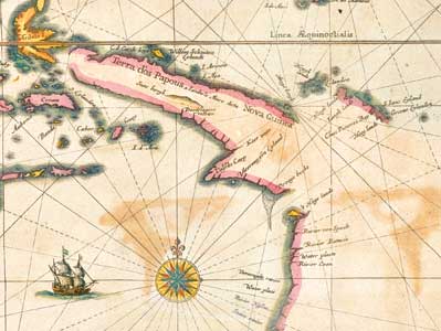
India quae Orientalis dicitur, et insulae adiacentes......[India which is called the Orient and adjacent islands...], Amsterdam, [1641?].
Hendrik Hondius
handcoloured engraving
India which is called the Orient and adjacent islands
The map records the voyage of Jan Carstenszoon on the ship Pera along the west coast of Cape York, 1623. Bottom right is New Guinea and the west coast of Cape York: 't Hoge landt (High land: Prince of Wales Island); Batavia River (Albatross Bay; Weipa); Coen River (Archer River); Vareenighde River (Mitchell or Coleman River); Staten River (probably the Gilbert River rather than present-day Staaten River). In the middle at the bottom can be seen Eendracht Land, Dirk Hartog's discovery in 1616.


