


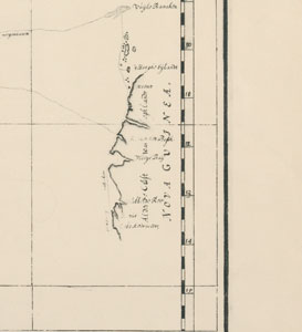
Chart of Duyfken's voyage, 1606. Monumenta cartographica...The Hague, 1933.
F.C Wieder
plate 125
ML XX/15 v.5
Chart of Duyfken's voyage
The original chart compiled at the time of this voyage is no longer extant. This is a reproduction of a late seventeenth century copy of that chart. The legend reads: 'This map shows the route taken by the pinnace Duyfken on the outward as well as on the return voyage when she visited the countries east of Banda up to New Guinea'. The landmass named Nova Guinea at far right is the west coast of Cape York which was assumed to be a continuation of New Guinea. Willem Janszoon was captain of Duyfken.