
 This
is the first printed map to include Cook’s discoveries on Endeavour,
1768–1771. It was engraved in early 1772. No other copy exists in Australia and
there is only one other in the world.
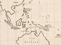
This
is the first printed map to include Cook’s discoveries on Endeavour,
1768–1771. It was engraved in early 1772. No other copy exists in Australia and
there is only one other in the world.
The chart was prepared for Joseph Banks and it is not clear why he arranged this. There is no evidence that it was ever formally published; rather, copies were made for Banks’s private use probably as a kind of prospectus for the proposed second voyage to the Southern Ocean.
Surprisingly, though, Cook’s major discovery that New Zealand was not part of a great southern landmass and his successful charting of the east coast of the Australian mainland are not features of this chart but, instead, a largely empty Pacific Ocean.
Banks had revelled in the botanical voyage of a lifetime on Endeavour
and now had a burning ambition to undertake a second voyage. One theory is that,
by visually demonstrating how much more there was to discover, this map
bolstered his arguments. The Admiralty did mount a second voyage, again
selecting Cook as leader. Banks demanded extensive alterations to the ship, to
accommodate his entourage, to the extent that it almost toppled over. The
Admiralty put its foot down and Banks went off in a huff.
The great Pacific Ocean, 1772
< Previous Exhibit | Back to The Exhibits page | Next Exhibit >