
 This
rare chart, one of only three known copies, shows the Dutch discoveries on the
west and south coast of Australia up to 1628. Although dated 1618, later
information has been added to an earlier copperplate without changing the date.
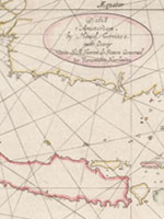
This
rare chart, one of only three known copies, shows the Dutch discoveries on the
west and south coast of Australia up to 1628. Although dated 1618, later
information has been added to an earlier copperplate without changing the date.
The first landing on the west coast was by Dirk Hartog in 1616 at Shark Bay where, on the island that now bears his name, he left the famous pewter plate recording his visit. The last landing recorded on this chart was that of Gerrit de Witt in 1628 near present-day Port Hedland. The chart is particularly valuable for its recording of the voyage in 1627 of the ship Gulden Zeepaert (Golden Seahorse) along the south coast to the Great Australian Bight, as far as the islands of St Peter and St Francis. This coast became known as Pieter Nuyts’ Land, after a Company official who was on board.
Hessel Gerritsz was the Chief Cartographer for the Dutch East India Company from
1617 until his death in 1632.
Display item Chart of the Malay peninsula …, 1618 with additions to 1629
< Previous Exhibit | Back to The Exhibits page | Next Exhibit >