
 This
is the first map of New Zealand. Viewed from far left to right is the west coast
of the North Island, north to south, the break representing Cook Strait, and
then a portion of the west coast of the South Island, north to south. Cook
Strait was a supposition rather than an observation.
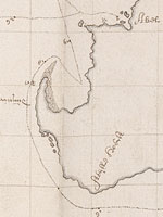
This
is the first map of New Zealand. Viewed from far left to right is the west coast
of the North Island, north to south, the break representing Cook Strait, and
then a portion of the west coast of the South Island, north to south. Cook
Strait was a supposition rather than an observation.
This chart is contained in the journal covering the voyage of Abel Tasman on the
ships, Heemskerck and Zeehaen, during 1642–43. Visscher was
the chief pilot on the voyage. The journal is not in Tasman’s hand but is a copy
made at the time by a clerk. Tasman was obliged to make six copies of his
journal for official purposes but only this copy and one other survive. The
journal in Tasman’s hand has not survived.
Display item Extract uittet journael …, 1642-43, compiled, 1643-47
< Previous Exhibit | Back to The Exhibits page | Next Exhibit >