
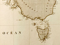
 Although
this chart was prepared in 1808 and engraved in 1812, the atlas in which it
appeared was not issued until December 1814. It forms part of the official
account of the voyage under Nicolas Baudin to Australia, 1800–1804. Baudin was
in Australian waters at the same time as Matthew Flinders.
Although
this chart was prepared in 1808 and engraved in 1812, the atlas in which it
appeared was not issued until December 1814. It forms part of the official
account of the voyage under Nicolas Baudin to Australia, 1800–1804. Baudin was
in Australian waters at the same time as Matthew Flinders.
When the first volume of the voyage account was published in 1807, the authors claimed the undiscovered south coast as a French discovery and named it Terre Napoléon. Flinders was outraged by this as he had in fact charted it first and he was further annoyed that his Spencer Gulf and Gulf St Vincent had been named after Napoléon and Josephine respectively. Presumably, Flinders did not see this chart, as he died in July 1814. In any case, his own map of Australia, which had been drawn in 1804, was published in the same month as his death before the issue of this atlas.
Freycinet changed the nomenclature for the second edition to reflect Flinders’
names.
Display item Voyage de découvertes aux terres australes … Atlas, 1812
< Previous Exhibit | Back to The Exhibits page | Next Exhibit >