
 This map was
drawn in Lisbon. Parts of Australia are duplicated on either side of the map, so
that if the map were wrapped around a globe the edges would overlap in line with
the east coast of Australia.
This map was
drawn in Lisbon. Parts of Australia are duplicated on either side of the map, so
that if the map were wrapped around a globe the edges would overlap in line with
the east coast of Australia.
The map of Australia shows the discoveries of the Dutch in the seventeenth century. No further charting of the Australian coastlines would take place until James Cook did so in 1770.
‘Terra de lesso leco’ is a vastly distorted representation of the Japanese island of Hokkaido deriving from a voyage of 1643. The earlier Spanish misrepresentation of California as an island is repeated here, as is the large extent of the Solomon Islands (Terra de Quiros).
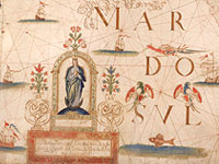
The place names are mainly in Portuguese, with Dutch names appearing in the
Portuguese or Spanish form. Images, both real and imaginary, are scattered
across the sea and landscape, including saints (Antony, John the Baptist, and
Francis), galleons, townships, animals and sea monsters. Below Africa is the
Portuguese Coat-of-Arms and an image of Atlas holding the earth.
Display item World map, 1706
< Previous Exhibit | Back to The Exhibits page | Next Exhibit >