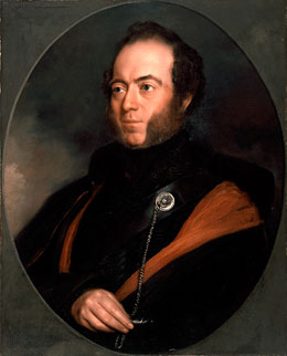
Sir Thomas Livingstone Mitchell
 Sir Thomas Mitchell, ca. 1830s, by unknown artist
Oil painting, ML 24
Surveyor-General of New South Wales from 1828-1855, Sir Thomas Livingstone Mitchell undertook four expeditions into the interior of Australia between 1831 and 1846. He published several accounts of his explorations. The State Library holds his collection of papers, including his diaries, journals of his expeditions and his field books.
Read more about Sir Thomas Livingstone Mitchell
Mitchell was one of many who travelled west during the winter of 1851 to visit the Ophir gold diggings along with his son, Roderick, and the government geologist, Samuel Stutchbury. Governor FitzRoy requested Mitchell to 'survey the extent and productiveness of the goldfield reported to have been discovered in the County of Bathurst'.
Mitchell surveyed the area around Summerhill Creek and the ‘town’ of Ophir.
He describes the scene when he arrives:
'I counted about 200 men at work, besides what were also in sight higher up and lower down the river, on the opposite bank, high above the river were numerous tents, as well as on the left bank of the river – and a bark home with placards about booking for mail, and about all kinds of stores sold there stood on river bank close to the diggers.'
Get the latest Flash player to view this interactive content.

Transcript: Selection from Sir Thomas Livingstone Mitchell's diary, 1851, Manuscript, ML MSS C71
[Page 1]
Sunday, June 1 1851
We arrived without impediment at Emu Ferry about 2 ½ oCk PM. Found the approach stopped up with drays and carts, the ferry boat carrying only three drays or carts at a time – The sun had set before our team arrived – Then a restive horse in the cart just before us delayed us half an hour - when at length embarked in the punt, the puntman would take a fourth – and threatened to “rush” our horses if we did not take them on a line until he embarked the fourth cart, This I refused to do and he persisted in embarking it, however our horse fortunately stood quietly – and we got access without further hindrance. Stopt at the New Inn at Emu – a town planned by me many years before – Wrote to Major Russell suggesting a bridge of Boats to be put across the Nepean – for which passage by a bridge a private Bill for taking toll was proposed last Session of Council – A great encampment of people with drays & carts laden with stores surrounded the Inn and lined the road on both sides of the mountain pass – the past.
Monday, June 2nd 1851
Ascended the mountain Pass which Sir Richd Bourke called Mitchells Pass – many carts and drays were on their way- our light carts passed them all – Met a man returning who said he was returning to his work, that he did not think people were averaging 9 sh. a day. The people going towards the mining were in general in parties of 5 or 6 with a heavily laden cart which at steep places they pushed behind – A heavy wooden or iron cradle was to be seen on all of them – Some carts carried five or six of these . We found the road along the mountains tolerably good – but water along the first part was very scarce – We bought some at a public house for 6d a bucket – They said it was brought four miles. We reached the Weatherboard Inn at dusk. The horses rather distressed. I was somewhat disappointed to find the old bridge still in use and the road unaltered where I had marked out and shown to Capt Bull an important improvement in the line and new site for the bridge seven
[Page 2]
years before, by which two hills cd. have been avoided and the road shortened and made to pass by the Inn door instead of at a distance as at present.
Tuesday, 3rd June 1851
Went out rather late from the Weatherboard Inn that the horses might refresh the more.
[In the evening Mr. Peter White – “stick to your hole” – and the strange gentleman with his 4 masons & £150 outfit – ].
We met many groups of two or three returning from the Diggings, all admitted there was plenty of gold – but that they could not stand the cold or pay the licence or as one man said, could not make wages out of it. There was a manly cheerfulness under this disappointmt. conspicuous in all these persons returning highly characteristic of fine feeling. One poor fellow – limping with one foot and thin pale and meagre only said – There was plenty of gold but – he “could not bear to wait!” The crowds going forward covered the road with their overloaded carts which some pushed behind, others drew in front, harnessed to the shafts – Sieves – kettles – tinpots – and cradles always appeared on these loads – and many clumsy hands carried guns apparently for the first time. The air was redolent of tobacco. We reached Blackheath at an early hour.
Wednesday, 4th June 1851
This morning an old sergeant with a Waterloo medal passed along the road or highway to join the Mounted Police – His whiskers were much greyer than mine - He knew me. We found the road very good down Mt. Victoria and indeed all through – but the long pull up from the Cox River is distressing from its uniformity. The descent to it is what I suppose the Bathurst people meant by Lambies Hill – is still worse because more continuing still. The only remedy by which all these mountains may be avoided is by making a railing in the direction suggested by me to General Darling for a great road to Bathurst, mainly up the Valley of the Grose – through a tunnel of a mile under Darlings Causeway and down the Valley of the Fish River crossing it five times. We reached the Inn at Solitary Creek about sunset.
(Subsequent arrivals – novel style of black - guardian worse than New [indecipherable]).
The rocks about the river Lett and Cox’s River seemed likely to be auriferous.
[Page 3]
Tuesday, 17th June 1851
This morning the misted party set off early. I set forward to take up the section line I had already marked and levelled (with barometer) to a hill 5½ miles from Molong while Mr. Davidson & my son conducted the party and equipment by the Guanna hill route to Nandillion Ponds there to encamp. The day was very stormy and settled into very heavy rain about 3 P.M. I continued my examination of the section line to a high summit of a range of rugged hills – 6 miles E. by compass from the marked tree on the Nandillion Ponds. I found most part of the country quartzose – and in parts the schist and clayslate cropping out – places there were white with fragments of quartz rock. I returned by the marked line (after measuring about 6 miles) and found the camp established, and tents pitched at the place appointed by the Nandillion Ponds. It rained very heavily as we returned and also during the night.
Wednesday, 18th June 1851
Returned to the marked tree on the hill where I yesterday left off accompanied by Mr. Davidson there to resume the marking and measuring of the section. Still the weather was very unfavourable, thermometer very low. Marking onward from that hill, we came upon the old road to Wellington at less than two miles. The country was still more quartzose than what I crossed before – quartz & chist everywhere. The highest part of the country was beyond Simpsons (or Wellington road) and not rugged except in the hollows – but rather broad at the upper part with long gently sloping vallies. The country beyond this (which was called the Mullin Range) broke into deep and steep ravines with isolated summits. I closed my section line at a turn in a water-course which we followed down, and was were led by it into a better sort of country – and soon came upon the road to “the Diggings”. The road was deep in mud, and the miners dray tracks were very different from the person far between trains of its wheels in the bush. Two drays with heavy trains & many men appeared in a steep slope in the road before us. We had fallen into the stream of population flowing to the Gold, and life seemed to go with it. We stopped for the night at a hut 3 miles from the diggings where Mr. Davidson promised us shelter for the night. Our horses were hobbled and turned out at great risk and where
[Page 4]
there could scarcely be said to be any grass. Thursday, 19th June, Mr. Stutchbury called on me and accompanied me to the diggings – Just as I expected to see – veins, bosses and steep hills of trap rock appeared in both banks of the river, in which there was a fresh which prevented me from walking a cross as I intended to visit Mr. Hardy. On a stony bough or link of the river, edged with river oaks (Casuarina), I counted about 200 men at work, besides what were also in sight higher up and lower down the river, on the opposite bank, high above the river were numerous tents, as well as on the left bank of the river – and a bark home with placards about booking for mail, and about all kinds of stores sold there stood on river bank close to the diggers. At this place there was a perpetual thoroughfare resembling the people at a tryst or fair, and amongst the natives who were there rather numerous. I was very glad to meet “Tommy Came Last” who accompanied me in my Expedition to the interior in 1836. He was now grown a powerful man in prime of manhood, but from Mr. Davidson I learnt that he was still remarkable for docility and good conduct. He was very lame from a sore foot. I ascertained that the aborigines have no name for gold – and that they had never known it, or seen it, until we shewed it to them. They accordingly call it “Gold” from us. This fact is clearly established altho’.
Friday, 20th June 1851
This day we proceeded to try a set of cylinders at gold working at a spot in the Nandillion Ponds which presented favourable indicating – but not a speck of gold could be found. I felt unwell yesterday and this day – a swimming in the head and intense head-ache – which Mr. Davidson convinced me, arose from having cold feet: however that might be, this indisposition was by no means favourable to these operations I was engaged in at that time. My son shot a water-rat with web-feet such as we had not seen – and it was skinned and preserved for Mr. Agilby.
[Page 5]
Sunday, 22nd June 1851
Set off early and before it was dark we had encamped beyond the tents of Mr. Stutchbury near the auriferous river of Frederick’s Valley. Found in a dyke a trap rock near where we had pitched our tents, basaltic columns indicating that there, the trap rock so abundant in these parts, had been erupted.
Monday, 23rd June 1851
Rode with Mr. Davidson and guided by “Tommy Came First” to the Diggings by keeping near the banks of Lewis’s Ponds Creek. Selected the site for the township of “Ophir” and set Mr. Davidson to work. My son and I afterwards looked at the diggings and walked up from the junction several miles. In general the diggers said they were not successful.
[Page 6]
Tuesday, 24th June 1851
Mr. Davidson having plotted his survey of the ground, I planned the streets and allotments for the Town of Ophir – and wrote a despatch to the Colonial Secretary to accompany this plan for the Town.
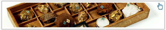
Mr. Davidson bought for me a specimen of quartz & gold found in the river for £2 – also one still more beautiful of bluish quartz – for £3. He told me about another he had seen with rubies set in it by nature for which I give him a cheque for £2 to buy it for me which he effected.
Received from the office at Sydney a second Aneroid barometer for which I had written to Mr. Halloran. Robt. Whiting formerly one of my exploring men brought me the Aneroid from Molong.
Wednesday, 25th June 1851
Sent off the despatch and plan addressed to the Colonial Secretary by post. Wrote also a few lines to Colonel Barry about Roderick and enclosing two applications from Robt. Whiting for cattle-runs.
This day I resumed the measure of my section line from Molong, which, I found, passed within a few hundred yards of my present camp – but which ran out to a point in a bend of the river, far below the diggings. I had hard work to scramble over the ground near the river – left a man with my horse a mile & a half back from it, and finally got to the river. I found on one of the heads near the river, the old conglomerate rock of the interior which Mr. Lonsdale formerly described as “Very hard rock consisting of grains and small pebbles of quartz cemented in a hard ferruginous matrix probably felspar”. This rock appears to have also engaged Mr. Stutchbury’s attention for he had previously informed me that he had found it (describing it exactly) in the [pass?] of Bellarida between the Lewis Ponds & Macquarie a few miles above their junction. He said he had reported it to Mr. Thomson as being probably rich in gold.
[Page 7]
Thursday, 26th June 1851
Mr. Davidson went to arrange about obtaining some supplies at the Diggings. I accompanied Mr. Stutchbury and my son to the bed of Frederick’s Valley Creek, and saw Mr. S. wash several pans of river deposit in all which small particles of gold were found. We also tried my cylinders with little success.
In returning, we found that the trap rock overlay the slaty rocks with [indecipherable] separation – easily to be traced. The small chrystels (like gunpowder) which always accompany the gold workings – Mr. S. shewed me appear on the surface of the ground wherever gold occurs. He called them carburet of Iron, and said they were as much lighter than gold, as to be easily washed away from the gold in the pan.
Friday, 27th June 1851
I crossed the river early at the Diggings, and ascended the ranges on that side – measuring and taking angles from the highest summits. I then fixed several very important heights, connecting them with the Canobolas. All the features are curiously conform to the outcrop of the slaty rocks which all range with remarkable uniformity about 20c W. of North (“Magnetic”). Saw a big ridge of quartz – a lode or vein – no doubt – running in the same direction. I fixed the loftiest mass of the Mullin Range – and intersected that bend of the river, where my section from Molong terminates. In descending I called on Mr. Hardy the Commissioner who shewed me some fine specimens of Gold pebbles and sold me one, I close, for £3.16.- weighing against a ½ a quartz pebble of the same size to obtain the weight of the gold only. Mr. Davidson this day chained the river downwards from Ophir in order to connect it with my section line from Molong – connecting it also with Mr. Laws E. boundary line.
I observed this morning, a fine point of view for a drawing of the Digging scene and regretted much that my time did not admit of my taking it.
While on this journey to the diggings, Mitchell collected a number of gold samples.