


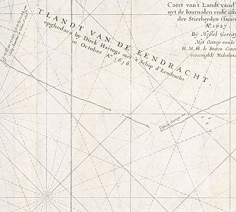
Caert van't Landt van d'Eendracht...[Chart of Eendracht Land...], Amsterdam, 1627.
Hessel Gerritsz,
engraving
ML ZM2 850/1627/1
Chart of Eendracht Land
North is on the left hand side. The inscriptions read (left to right): 'Willem's river [just south of North West Cape], visited by the men of the ship Mauritius, July 1618; Land of the Eendracht, discovered by Dirk Hartog with the ship Eendracht in October 1616; Dirk Hartog’s roadstead; Fr. Houtman's Abrolhos, sailed to in July 1619; Turtle Dove [Turtle Dove Island, discovered by ship Turtle Dove, 1624]; dunes, above with trees and bush; Land of the Leeuwin, sailed to in March 1622; low like drowned land; low dune land’.