


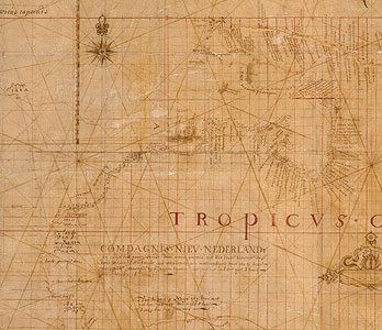
Bonaparte Tasman Map, 1640s.
Unknown cartographer,
Original manuscript on Japanese paper
ML 863
Bonaparte Tasman Map
The legend top right reads: 'Map: these lands were discovered by the Company explorers except for the northern part of New Guinea and the west end of Java. This work thus put together from different writings as well as from personal observation by Abel Janszoon Tasman, year 1644, by order of His Excellency the Governor General Anthony van Diemen'. The legend on Western Australia reads: 'Company's New Netherland. In the east of the great land of New Guinea with the first known South Land being one land and all joined together as can be seen by this dotted track of the yachts Limmen, Zeemeeuw and...Bracq Year 1644'. The legend on Tasmania reads: 'Anthony van Diemen's Land this is sailed and discovered with the ships Heemskerck and Zeehaen under command of the honourable Abel Tasman in the year 1642, the 24 November'.