In search of rich lands : the Dutch
Europeans had been searching for rich new lands in the Southern Hemisphere long before Captain James Cook arrived on the east coast of Australia in 1770. Dutch sailors made their first landfall on Australian shores in 1606. By the time Cook arrived nearly 170 years later, the Dutch had charted all but the east coast of 'New Holland'.
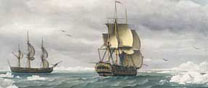
In 1605 Willem Janszoon (c.1570-c.1638) was sent on the ship Duyfken to discover the 'great land Nova Guinea and other unknown east and south lands' for the powerful Dutch East-India Company (Vereenigde Oost-Indische Campaignie or VOC), the world's largest trading company at the time. Janszoon charted parts of New Guinea's south coast and then sailed past the entrance to Torres Strait and landed on Cape York peninsula, believing it was a continuation of New Guinea. A number of accidental encounters with Australia's western coast followed, however it was the voyages of Abel Tasman which were the apogee of the Dutch charting of Australia.
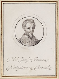
Abel Tasman (1603?-1659) is credited with the European discovery of Tasmania, New Zealand and Fiji. In 1642 Tasman was commissioned by Anthony van Diemen, the head of VOC in Batavia, to explore the southern oceans and find profitable new trading markets for the Company. On his first voyage in 1642-1643, with two vessels Heemskerck and Zeehaen and a crew of 110, Tasman charted Tasmania (which he named Van Diemen's Land), the west coast of New Zealand, parts of Tonga and Fiji, and the north coast of New Guinea, becoming the first European explorer to do so. It was a remarkable voyage, but he had not found the famed riches sought by the Company.
On his second voyage in 1644, Tasman unsuccessfully tried to chart a passage to the rich trading markets of South America. Although he charted the south west coast of New Guinea and much of Australia's previously unknown northern coastline, the exploration was deemed unsuccessful. The famous and significant Tasman map is one of few documentary sources relating to this voyage.

The original journal kept by Abel Tasman on board his ship Heemskerck, during the first journey of 1642-1643, has not survived. The State Library's Huydecoper manuscript is an edited copy of the missing original journal, compiled sometime between 1643 and 1647. It was official practice to make exact copies of important documents for the Dutch East India offices in Batavia and the Netherlands.

Disappointed that Tasman had failed to find rich trading routes, the Dutch lost interest in Australia and turned their attention to America. This left the way clear for English navigator Captain James Cook to chart the east coast of Australia in 1770.
> View a Gallery of Maps including maps by Dutch cartographers Hessel Gerritsz and others