
 This
detailed plan of a Sydney city block is from a series of maps created for the
Fire and Accident Underwriters’ Association of New South Wales. The Association
was responsible for assessing fire risks and setting minimum rates for
insurance.
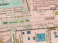
This
detailed plan of a Sydney city block is from a series of maps created for the
Fire and Accident Underwriters’ Association of New South Wales. The Association
was responsible for assessing fire risks and setting minimum rates for
insurance.
The series includes over 200 block plans stretching from Circular Quay and Darling Harbour to Central Railway Station and Pyrmont. They were originally created in 1919 and updated as new buildings were constructed or as buildings changed hands. Details of construction materials, building heights, stairways and proximity to fire hydrants are all clearly marked. Alterations to a plan were made by pasting coloured updates over the old sheet. Block 150, on display, shows changes to the area up to 1940.
Created as practical planning documents, these maps allow us to imagine the
activity and appearance of a city block as it was seventy years ago. Despite
recent changes to the area and the creation of Pitt Street Mall, a number of
major store owners still occupy buildings in the area, including Dymocks and
Soul Pattinson. Even more intriguing are the references to rooftop gardens,
billiard saloons and coffee inns.
Display item City of Sydney, 1920
< Previous Exhibit | Back to The Exhibits page | Next Exhibit >