
![Chart of Port Jackson New South Wales Survey'd by Capt.n Iohn [sic] Hunter Second Captain of His Majesties Ship the Sirius 1788.](/archive/images/exhibitions/2006/eora/sm/10.jpg)


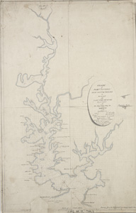
Chart of Port Jackson New South Wales Survey'd by Capt.n Iohn [sic] Hunter Second Captain of His Majesties Ship the Sirius 1788.
Drawn from the original by George Raper (1769-1797).
Manuscript chart, pen and ink, watercolour
Ref: ZM2 811.15/1788/1
Chart of Port Jackson New South Wales
After the first survey of Port Jackson in February 1788, George Raper, a 19-year-old midshipman and watercolour painter, copied this chart from one drawn by his commanding officer, Captain John Hunter of HMS Sirius. Freshwater sources are marked and inlets given English placenames, some of which are still familiar: Farm Cove, Camp Cove, Rose Bay and Manly Cove. Other names are no longer used, such as Garden Cove (Woolloomooloo Bay); Keltie Cove (Double Bay), named for James Keltie, sailing master of HMS Supply; and Blackburn Cove (Rushcutters Bay), after David Blackburn, sailing master of HMS Sirius.