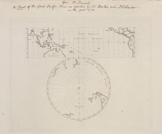
The Great Pacific Ocean, c. 1772
Printed map (2 maps on one sheet) London Purchased 2008 M2 910/1772/2
Printed map (2 maps on one sheet) London Purchased 2008 M2 910/1772/2
Maps from Cook's first voyage were first published in 1773, and the east coast of New South Wales was first shown on Dunn's world map published in November 1772.
John Abraham Bayly, fl. 1755-1794
(fl. Is used by historians as an abbreviation for the Latin word ‘floruit’ meaning living at a certain time or ‘flourished’, to indicate when a person was influential; it is normally used only when dates of birth or death are unknown)
Fifty
copies were printed on French paper, and fifty on thinner paper. Until relatively
recently, the sole known copy was the Library of British Museum's, printed on
lighter paper.
The scale of the map is approx. 1:90 000 000
Also known as ‘Banks' chart of the great Pacific Ocean’ or the ‘Banks map’
Acquired
in 2008 from the Captain James Cook Collection of Robert and Mary Anne Parks.
The
1974 discovery of Sir Joseph Banks’ hitherto unknown eighteenth century
engraved copper plate of ‘The Great Pacific Ocean’ in the Botany Library of the
British Museum (Natural History) is the foundation of a publication titled The Banks/Cook Portfolio edited by
Pamela Gilbert which was first published in 1990.