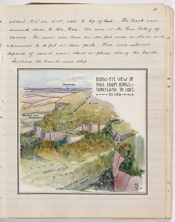
Birds-eye view of pass from Kings Tableland to Cox’s River
1912
MLMSS 4457 / MLK 3281
Manuscript diary
MLMSS 4457 / MLK 3281
Manuscript diary
The conservationist and architect Myles Dunphy OBE (1891-1985) was a passionate advocate for New South Wales’ nature reserves, and particularly for the Blue Mountains. His love of nature started at a young age after spending much time with his family exploring the bushlands near their home in the southern suburbs of Sydney.
In 1914 Dunphy and his friend Bert Gallop found the Mountain Trails Club which marked the beginning of his lifelong commitment in connecting urban residents with the natural world. Through his association with the Club, Dunphy was able to create a series of maps for newly developed trails within the greater Blue Mountains area. *
‘Birds-eye view of pass from Kings Tableland to Cox’s River’ is an illustration of Dunphy’s route from Wentworth Falls to Cox’s River from his travel journal dated 1912. In the classic style of Dunphy’s cartographic work, this map provides topographical information, and names the peaks, valleys and rivers reflecting the difficulty of the walk. *
Footnotes
* Australian dictionary of biography http://adb.anu.edu.au/biography/dunphy-myles-joseph-12446