Sketch shewing the different lines of road descending from the Blue Mountains towards Bathurst
1855
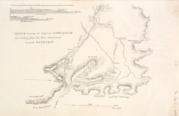
A 331 (opp. p 20)
Pencil and ink drawing
When the controversial Scot Sir Thomas Livingstone Mitchell arrived in New South Wales in 1827 to take up the post of assistant surveyor-general, the Survey Department was in shambles. Mitchell quickly introduced new techniques and technologies to the ill equipped and under resourced department at the crucial time when the expansive inland areas of the colony were being opened up by settlers.
Mitchell created this plate for Progress in Public Works & Roads in NSW 1827-1855, a report that was probably used as part of the evidence prepared for an inquiry into the accuracy and efficiency of the Surveyor-General's Department. This document is based upon the sketches Mitchell made between 1827 and 1830 when he discovered and marked out a new descent from Mount Victoria to Bathurst on the western side of the Blue Mountains.
This map compares two passages across the mountains: the ‘Present Road’ (which was then in use) created by engineer William Cox in 1815, and ‘Major Mitchell’s marked line’. Cox’s route avoided the worst of the ridges, but forced people to travel in a wide, steep arc around Mount York which headed north then descend south-west into the Hartley Valley.
‘Victoria Pass and thence to Bathurst.’
The
authoritarian Governor Ralph Darling (1772-1858), commissioned the Roads and
Bridges Department to find a better route from Mount York to the Hartley Plain.
As head of the department Sir Thomas
Mitchell was determined that he himself would have the honour of improving the
colony’s most economically important highway.
In
May 1830, Mitchell and assistant surveyor Phillip Elliot, arrived at Mount York
and began the search for the best line of descent. On June 4, Mitchell located
a route starting between Mount York and Mount Clarence and named this middle
point Mount Victoria. His plan involved the construction of a causeway between
two ridges – he was so convinced this route was the best and most efficient descent
that he ordered convict chain gangs to begin work on the road immediately.
By
beginning work on the road, Mitchell was directly disobeying Governor Darling’s
orders, which were to mark out the line from Mount York to Bathurst, then seek
further instructions before any work began. On June 23, he sent a report to the
colonial secretary explaining the Mount Victoria descent, and received a
strongly worded reply a month later, instructing him to cease all work on this
part of the road. Darling was concerned that in time, a better route would be
discovered, and didn’t want to waste resources on an extravagant engineering
project. Darling preferred to put his Government’s resources towards improving
an alternative descent from Mount York to Collit’s Inn which was already in
progress.
Despite the resistance
from Darling,Mitchell persevered with his vision, and work on
Victoria Pass following the route of ‘Major Mitchell’s marked line,’ started in
1830, finishing in 1832. Victoria Pass is considered one of the most
challenging and important engineering projects to occur in the history of NSW.
It is still in use, and remains almost unchanged today.