Blaxland's route across Blue Mountains, May 11th to 31st 1813
1937
M2 812.17p/1937/1
Map
M2 812.17p/1937/1
Map
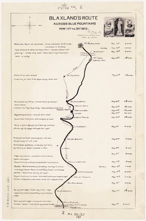
By 1813 Gregory Blaxland had already made two previous expeditions into the foothills of mountains to explore the territory. Based on his knowledge of the terrain, he concluded that it might be possible to cross the Mountains following a ridge running between the Warragamba and Grose Rivers. Blaxland, Wentworth and Lawson were successful in their crossing because they followed the ridge lines across the mountains, avoiding the most of the steep, disorientating valleys.
This map was produced in around 1937. It is based on a map in a 1913 edition of Blaxland’s journal edited by Frank Walker, and shows the route taken by Blaxland, Wentworth and Lawson across the Blue Mountains in 1813. It also includes notes on the journey, and distances travelled each day, alongside what became the Main Western Road which is now the Great Western Highway.