Curio

State Library of New South Wales

Port Jackson, New South Wales

1822
Printed map
Sydney: Lithographed by R Clint, [182-?]
Bequest of Sir William Dixson, 1952
DL Z/Cb 83/1

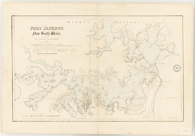
In 1817 John Septimus Roe was posted as a master's mate to the surveying service in NSW, then under the command of Phillip Parker King. He arrived in the colony in September and over the next three years conducted three hydrographic coastal surveys, which included circumnavigating Australia. He was appointed lieutenant in April 1822, the same year he made this chart.

The chart provides a survey of Port Jackson from the Heads west to 'The Flats' (Homebush Bay). It shows the soundings, or the depth of the harbour, recorded in fathoms, tidal changes and the western and eastern channels near the entrance to the Heads.

Roe died on 28 May 1878. His obituary in the Perth Inquirer and Commercial News, stated that 'His hands were clean: he never used the privileges of his post unduly to his own advantage or the advancement of his numerous family'.

As a schoolboy, Roe wrote lengthy letters to his parents. He remained a devoted and enthusiastic letter writer throughout his life, and also a devoted diarist.

Roe began his career as a naval officer, but was soon noticed for his carefully drawn charts. On long and often difficult sea voyages, he found relief and pleasure in keeping logbooks, writing letters and making charts and sketches.

In four major voyages, Roe assisted Phillip Parker King to complete the work of Matthew Flinders. These voyages charted the coastline from Hervey Bay, Queensland, to Torres Strait and from Cape Arnhem on the northwest coast of the Gulf of Carpentaria, west along the north coast and down the south coast to Cape Leeuwin, at the southwest corner.