Plan of the allotments of ground, granted from the Crown of New South Wales
1814
Printed map
London, 1814
Bequest of Sir William Dixson, 1952
DL Z/Cb 81/1
Printed map
London, 1814
Bequest of Sir William Dixson, 1952
DL Z/Cb 81/1
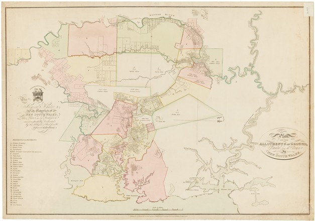
This map shows land grants made in the Sydney region to 1813. It was created to accompany the booklet, An Accurate List of the Names of the Land-holders in the Colony of New South Wales (corrected to 1813). Together, the coloured map and list could be purchased for 10 shillings and sixpence; the list alone for 6 shillings and sixpence.
The two large plots closest to Sydney, 7 and 9 on the map, represent the first land grants made in the Surry Hills area. Major Joseph Foveaux received 105 acres (42ha) in 1792 and Commissary John Palmer received 90 acres (36ha). The area marked Green Hills had been named Windsor by Governor Macquarie in 1810, but on the basis of this map it seems that the name had not yet been adopted.
Many place names on the map are no longer used. For example, the area marked Liberty Plains now encompasses the Municipality of Auburn and includes the modern suburbs of Lidcombe, Auburn, Newington and Homebush Bay. The area named Bulanaming’ (point H), is located between Sydney, the Cooks River and the Parish of Petersham.