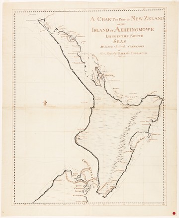
A chart of part of New Zealand or the Island of Aeheinomowe lying in the South Sea
1770
Manuscript map
Bequest of Sir William Dixson, 1952
DL SPENCER 166
Manuscript map
Bequest of Sir William Dixson, 1952
DL SPENCER 166
In mid August 1769, after almost four months in Tahiti, Cook sailed south into uncharted waters, and on 7 October 12-year-old cabin boy Nicholas Young sighted land. Honouring his promise to reward the first person to sight land, Cook named the headland Young Nicks Head after him.
Two days later Cook landed at Poverty Bay, where skirmishes resulted in the deaths of several Māori. He then sailed south to Cape Turnagain, then north, pausing at Tolaga Bay and Anaura Bay before rounding East Cape to Mercury Bay. After a week in the Bay of Islands, he turned the top of the North Island in a storm, and sailed down its west coast, before heading west in April 1770 in search of Van Diemen’s Land. Forced north by winds, his expedition came upon the east coast of Australia.
Observing the land sometimes from well out to sea, Cook made two famous errors in these charts: he charted Banks Peninsula as a probable island and Stewart Island as a probable peninsula. Both errors can be seen.