Orbis terrarum nova et accuratissima tabula
1666
Printed map, hand coloured
Amsterdam: Pieter Goos, 1666
Bequest of Sir William Dixson, 1952
Z/Cb 67/2
Printed map, hand coloured
Amsterdam: Pieter Goos, 1666
Bequest of Sir William Dixson, 1952
Z/Cb 67/2
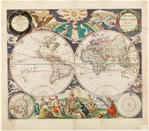
This lavishly decorated map was originally published in De Zee-Atlas ofte Water-Werel (The Sea Atlas of the Water World) in Amsterdam in 1666, considered one of the finest sea atlases of its time. Along the top edge is a flock of birds, including a goose, flying towards the sun, and along the base are allegorical figures representing the four seasons. The map includes insets of the North and South poles, the empty South Pole region titled simply ‘Australis Incognita’. The north western portion of North America is not charted and California is drawn as an island. The continent of Australia, named Hollandia Nova, includes the southern tip of Tasmania as charted by Abel Tasman.
The engraver and cartographer Pieter Goos was a member of an important mapmaking dynasty, begun by his father Abraham Goos, who published numerous globes, land and sea maps. Following Pieter’s death, later editions of his maps and atlas were published by his widow: few women were trained members of the publishing guilds, but some worked alongside their husbands for decades and inherited their guild rights.