Curio

State Library of New South Wales

Oost Indien wassende-graade paskaart

167?
Printed map on vellum
Amsterdam: Pieter Goos, [167-?]
Bequest of Sir William Dixson, 1952
Z/Cc 67/1

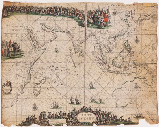
This rare sea chart extends from the Cape of Good Hope to the far east of Australia. It is based on an earlier map by Goos from 1658, thought to be the first to name all the Dutch discoveries in Australia, including those made by Abel Tasman during his voyages of 1642–43 and 1644.

This chart was designed as a showpiece, but less elaborate versions would have been used by the navigators of the powerful Dutch East India Company ships sailing between the East Indies and Europe. The fastest route to the East Indies was to travel south to the Cape and then sail east 3000 nautical miles with the Rroaring Fforties before turning north towards Sunda Strait and Java to Batavia (Jakarta). Without the ability to judge longitude with accuracy, a number of ships were wrecked on the west coast of Australia.

Rich discoveries

The Dutch explorer Abel Janszoon Tasman is credited with the European discovery of Tasmania, New Zealand and Fiji. In 1642 he was appointed by the governor-general of the Dutch East Indies, Anthony van Diemen to lead a voyage of discovery to the southern oceans. The purpose of the mission was to search for ‘the great southern land’, believed to possess great riches and resources. The Dutch East India Company also had a commercial interest in locating new trading partners and identifying faster and safer trade routes to Europe, particularly a Pacific route across to South America.

On his 1642–43 journey, Tasman sailed from Batavia (now Jakarta) in Indonesia along Australia’s south coast, around the southern tip of Tasmania, and on to New Zealand, Tonga and Fiji before returning to Batavia via the north coast of New Guinea. On a second voyage, in 1644, he charted much of Australia’s northwest coast and the southwest coast of New Guinea. Both voyages are accurately documented on this chart.

From the high seas

Today 13 do: Observed latitude 42 degr: 10 min: Longitude 1188 degr: 28 mi … 
In the evening we deemed it advisable
and ordered our makes
to maintain the Southeast Course
as long as it remains quiet
but to run due East if the Breeze should freshen
in order not to fall ashore
and to prevent any accidents as far as we can
for we sustain that this Land cannot be made from this side
and that on account of the High open sea
which is running into it with huge hollow waves and a heavy swell: unless there should happen to be some land-locked bays on side
in the first watch four glasses having run out we shaped our Course Due East variation 7 degr:30 minutes/ northeasterly … *
From the journal of Abel Tasman, 1642–43 

Footnotes
* From ‘Extract Uittet Journael vanden Scpr Commandr Abel janssen Tasman, bij hem selffs int ontdecken van't onbekende Zuijdlandt gehouden', 1642–43, State Library collection, Safe 1/72