Curio

State Library of New South Wales

Tasman Map

c.a 1939-41

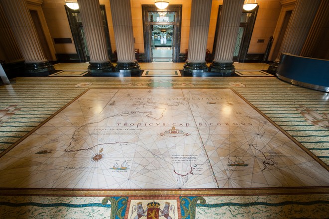
This mosaic shows the voyages made by the Dutch explorer Abel Janszoon Tasman in 1642–43 and 1644. It replicates the famous ‘Bonaparte-Tasman Map’, the first European map to largely depict western and southern Australia’s coastline and neighbouring Pacific islands. The original map, now one of the Library’s most prized possessions, was most likely based on a chart prepared by Tasman’s chief pilot and advisor, Franchoijs Visscher, probably some 40 years after the expeditions.

On his 1642–43 journey, Tasman sailed from Batavia (now Jakarta) in Indonesia along Australia’s south coast, around the southern tip of Tasmania, and on to New Zealand, Tonga and Fiji before returning to Batavia via the north coast of New Guinea. On his 1644 voyage he charted much of Australia’s north-west coast and the south-west coast of New Guinea. The routes are marked on the mosaic by dotted lines and the words ‘Abel Tasman’s passagie.’ Above the map are cherubs holding early navigation instruments, including celestial spheres, cross staff and compass. The cherubs at each corner represent the four winds.

Made of marble with inlays of brass and coloured marble granules, the mosaic took many hours of painstaking and accurate work to complete. It was created by Sydney’s leading marble and mosaic workers, the Melocco Brothers of Annandale, who also created all other marble work in the building.

During Tasman’s 1642–43 voyage he named the southern tip of Australia Van Diemen’s Land after Anthony van Diemen, the Dutch governor-general in the East Indies.

The ‘Bonaparte-Tasman Map’ on which the mosaic is based was once owned by Prince Roland Bonaparte, a 19th-centrury French traveller and geographer. It was presented to the Library in 1931 by his heir, Princess George of Greece.

The map features green Tasmanian serpentine, black marble from Yass, and Wombeyan russet marble. The Wombeyan marble was chosen to reproduce the paper colour of the original Tasman map of 1644.

In his speech at the official opening of the 1942 additions to the Mitchell Library building, the NSW governor, Lord Wakehurst, praised the Tasman mosaic as ‘a monument well worthy of the Australian craftsmen who have built it’. In reality, the team of craftsmen included a number of Italians interned as enemy aliens, who had to return to the internment camps once the mosaic was completed.

Tasman’s voyages were also depicted in a floor mosaic in the Amsterdam Town Hall. An engraving of the floor in a rare 1661 volume in the State Library’s collection is now the only known record of the floor, which was replaced due to wear from foot traffic.

Tasman kept journals during both voyages shown on the map. The full journal of the first voyage was lost, but two abridged versions survived. One of these is now held in the State Library. The journal of the second voyage was also lost. No copies are known to exist.