Atlas to accompany the official records of the Union and Confederate armies, compiled by Calvin D Cowles, 1891–95
Government Printing Office, Washington
NF911.73/2 Vol 3
The blue and the grey
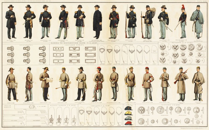
Bound within the atlas which accompanied
the official government report on the American Civil War (1861-1865), is an
illustration of the uniforms worn by both sides; the Union troops of the United
States and those of the south, the Confederacy.
In five years, unprecedented bloody
battles with names like Shiloh, Antietam and Gettysburg raged, dividing the nation. An
estimated 620,000 men, around 2% of the population lost their lives in the five
year war.
This
atlas (in 3 volumes), includes maps of all the Civil War battle sites. It was
published as part of the Official Records
of the American Civil War, prepared under the direction of the Secretary of
War, by Robert N. Scott and published between 1880 and 1901. This extensive
report runs to 70 volumes in 4 series. It includes correspondence, accounts of
all military operations and reports on prisoners. The Library holds some of
these volumes; however the entire report is available online at Cornell
University.
The other title of this report is, The
War of the Rebellion: a Compilation of the Official Records of the Union and
Confederate Armies. This is still seen today as a controversial title by
some in the United States.
Other names for the Civil War include; the
‘War between the States’, ‘War for Southern Independence’, ‘War of Northern aggression’,
‘States’
Rights War’. These names reflect
geographic locations and cultural sensitivities which still exist today.