The Papal edict of Tordesillas
By Emma Gray, 2014
In 1494 the Papal edict of Tordesillas divided rights to all
newly discovered lands between Portugal and Spain, based on an arbitrary line
running from pole to pole approximately 2,061 kilometres west of the Cape
Verde islands. The Spanish controlled
the area west of the dividing line. They established a base at Manila in the
Philippines and conducted lucrative trade between this new centre and their
colonies along the Pacific coast of North and Central America. Portugal
established successful trading routes between Europe and the East Indies.
In the seventeenth century the Dutch ousted Portugal from the East
Indies and dominated trade and exploration in the region up until the eighteenth
century. Spain concentrated on expanding their bases in Central America, Mexico
and Peru.
During the eighteenth century, other European naval powers,
particularly England and France, began the exploration of the Pacific regions in
search of trading opportunities, strategic bases and the legendary landmass of Terra Australis.
In 1767 as part of a voyage to circumnavigate the world, Captain Samuel
Wallis arrived in Tahiti on the Dolphin
claiming the Island for Britain with the name of King George’s Island. Later in
1767 the island was visited by Louis Bougainville who claimed the island
for France and named it New Cythera. Captain Cook reached Tahiti in 1770 on the Endeavour. Cook called the
island Otaheite.
Spanish activity in the Pacific region had diminished following the
Seven Years War(1756–1763), in which
they lost significant land, including Spanish Florida and islands in the West
Indies to the British. With the increase in British activity and potential
threat to their empire the Spanish Crown launched a series of exploratory
voyages to map and colonise several South Pacific islands, as well as to
explore and claim the American territories inland from their bases in
California and Mexico.
Gonzalez and Boenechea expeditions
By Emma Gray, 2014
The first expedition was by Felipe Gonzalez to claim Easter Island for
Spain, which he did in November 1770. He spent five days mapping the island.
Domingo Boenechea headed the 1772 Tahiti expedition and surveyed the
island, reporting in 1773 that it was suitable for a Spanish colony. The
Spanish called the island Amat’s Island after the Spanish Viceroy. In 1774 Boenechea
returned to establish the colony which was to be led by two Dominican friars. The
colony failed within a year, effectively ending the Spanish empire in the
Pacific.
Although the power of the Spanish Empire in the
Pacific had diminished Spanish interest in Pacific activities remained
significant. Between 1789 and 1794 the Spanish authorised a scientific
expedition by Alessandro Malaspina.
After a survey of the Spanish colonies in America, he sailed across the
South Pacific visiting Port Jackson in March 1793. Malaspina’s Political Examination of the English
Colonies in the Pacific, written on the return voyage, discusses the
potential impact of English colonisation on Spanish interests. Malaspina
concluded that any physical threat should be countered by establishing a strong
market in the colony for goods from the Spain’s American interests.
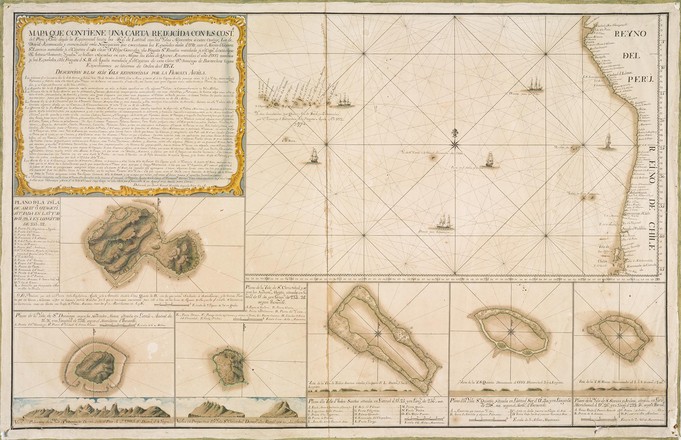
The most detailed known charts of the Spanish expeditions to Tahiti and Easter Island
By Emma Gray, 2014
Although the aims of the Spanish expeditions in the 1770s were
ultimately unsuccessful, the maps which remain documenting the activities and
settlements are significant both for their content and their rarity. The
collection contains the most detailed known charts of the Spanish expeditions
to Tahiti and Easter Island.
In Spain at the time, publishing maps and journals of exploratory
expeditions was subject to strict secrecy and censorship laws. Within a
generation of the expeditions, the Spanish American empire had collapsed, and
public interest in the history of the explorations had waned. As a result,
material known from this period is rare.
The extent of the discovery and charting of Pacific territories by the
Spanish is not as well-known as the English and French voyages. The
achievements of English, French and even Russian voyages charts of exploration
including private journals and charts were published and circulated widely. The
Spanish Government retained a tight control over information gathered from
their expeditions.
Around 1775 the charts in this collection were commissioned and
collected by Commodore Somaglia for his personal use as Commander of the South
Pacific Squadron of the Spanish Armada Real.
Joseph de la Somaglia was an Italian born officer in the Spanish Navy.
In 1770 he was appointed to a post in Callao, Peru as the Commandante de la
Esquadra of the South Sea. Somaglia was
responsible for the outbound security of Spanish vessels carrying silver and
gold to Europe. He also oversaw the expeditions to the Pacific including the
voyages of Domingo de Boenechea to Tahiti and the Polynesian Islands.
From a collection of 24 manuscript charts ...
From a collection
of 24 manuscript charts of the Pacific Ocean and South America, highlighting
the Spanish expeditions to Easter Island and Tahiti, 17623–1775
This
collection was assembled by Commodore Joseph de la Somaglia, Commander of the
South Pacific Squadron of the Spanish Armada Real between 1770 and 1778. The
charts document Spanish activity in the Pacific in the second half of the
eighteenth century particularly, the Spanish expedition to Easter Island under
Felipe Gonzalez in 1770 and two expeditions to Tahiti under Domingo Boenechea
in 1772–3 and 1774–5.
Since the
Papal edict of Tordesillas in 1494 the Spanish had regarded the Pacific as its
exclusive domain. In the eighteenth century this position was threatened by the
expansion of English, French and Russian exploration in the Pacific. In 1774 a small colony was established on
Tahiti consisting of two Franciscan priests. A year later the settlement was
abandoned and Spanish attempts to re-establish their foot hold in the Pacific
were abandoned.