This impressive wall map
By Emma Gray, 2014
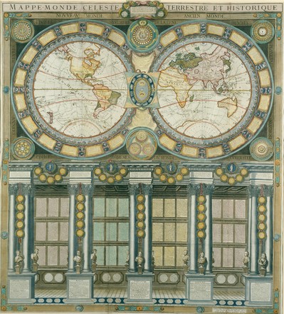
This impressive wall map, Grande
mappemonde céleste, terrestre, historique & cosmographique (Great celestial, terrestrial, historical and
cosmographical map of the world), contains a fabulous wealth of information
on all aspects of exploration and cartography, encompassing the astronomical,
geographical and administrative systems. It is one of a very few wall maps
engraved in the brief period between the voyages of Captain James Cook (between
1768 and 1779) and the French Revolution (in 1789). The map is a reissue of N.
Jaugeon’s magnificently complex and geographically current world map, published
in Paris in 1688.
N. Jaugeon was the first director of the French Académie Royale
des Sciences. At the turn of the seventeenth century, his map of 1688 was either
revised from an earlier plate, or newly engraved for Hubert Alexis Jaillot of
Paris. The Jaillot map was reissued by the Jaillot family of map publishers in
the 1730s. A newly reworked plate appeared in 1758, and was further updated in
1786 as the Grande mappemonde.
The 1786 map celebrates Captain Cook’s remarkable achievements on
three voyages of discovery. Australia’s east coast and America’s north west
coast are completed, and the routes taken by Cook and Captain Tobias Furneaux
(1735–1781) are shown in considerable detail.
The Grande mappemonde
was published by Louis Charles Desnos (1725–1805), with the latest scientific
discoveries added by Louis Brion de la Tour (1756–1823), the geographer to the
King of France. Desnos was one of the most eminent cartographers of his day,
and was the globe maker to the King of Denmark. Based in Paris, he was also a
publisher and bookseller, and produced many atlases and globes.
Desnos and Brion de la Tour collaborated on republishing the maps
of the Jaillot and Sanson families. The Grande
mappemonde is a very fine example of the popular large decorative wall maps
that were produced for the French commercial map trade. Throughout most of the
eighteenth century, France was the most important centre of map publishing, and
Paris in particular dominated in the production of fine wall maps.
The
Grande
mappemonde was purchased by the State Library of New South Wales in 1996.
Louis Charles Desnos
Louis
Charles Desnos (1725-1791) was one of the most prolific French mapmakers during
the 18th century Age of Enlightenment. Based in Paris, he was
appointed official cartographer to the King of Denmark, Christian VII, and sent
him a copy of most of his publications. During his life, Desnos was so prolific
and published so broadly that he gained a reputation for shoddy and undiscerning
workmanship. Ironically, he is now regarded as one of the most important
Parisian mapmakers of the period, probably due to his vast output.