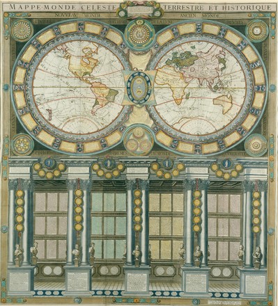
Grande mappemonde céleste, terrestre, historique & cosmographique, dediée au Roi, où sont représentés les differens systêmes du monde, 1786
Grande
mappemonde céleste, terrestre, historique & cosmographique, dediée au Roi,
où sont représentés les differens systêmes du monde, 1786
Louis
Charles Desnos
M4
100/1786/1
Paris:
Desnos, 1786
Hand
coloured printed map
This beautiful large wall map consists of six joined sheets. It is hand-coloured and features a twin hemispherical map of the world (including the routes of James Cook). The lavish borders are decorated with the signs of the zodiac, astronomical and astrological dials and wind points. The lower part of the map consists of text describing the geography of the three ancient continents, Europe, Asia and Africa.