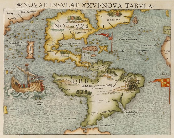
Novae insvlae XXVI nova tabvla
Novae insvlae XXVI nova tabvla
Sebastian Münster
Hand
coloured wood engraving
M2
122/1552/1
This map first appeared in 1540 in Sebastian Munster’s
publication of Ptolemy’s Geographia
and in later editions until 1552. It was also issued in many editions of
Munster’s Cosmographia from 1544 to
1628.
Munster’s map is the earliest to show the whole
continent of America and the first to use Magellan’s name, Mare Pacificum (Pacific Ocean). Magellan’s galleon, Victoria, is shown near the straits of
Magellan.
A recent acquisition
By Emma Gray, 2014
The Library
recently acquired this beautiful 16th century map of North and South America by
Sebastian Munster (1488-1552), German cartographer and scholar.
This map first
appeared in 1540 in Munster’s publication of Ptolemy’s Geographia and in
later editions until 1552. It was also issued in many editions of Munster’s Cosmographia
from 1544 to 1628. Cosmographia was the earliest German description of
the world.
Based on the
map’s title and details, it appears that this map was produced for a later
edition of Geographia, probably that of 1552.
Munster’s
map is the earliest to show both continents of America and the first to use
Magellan’s name, Mare Pacificum (Pacific Ocean). Magellan’s galleon, Victoria,
is shown near the Straits of Magellan.
A feature of the
map of North America is the dominance of the sea of Verrazzno – a
cartographical error created by explorer Giovanni da Verrazzano thanks to his
exaggerated description of the Pamlico Sound in 1524.
The map also
marks the first appearance of Japan (named Zipangri) on a map, before European
contact – it was based on the legends of early explorers such as Marco Polo.