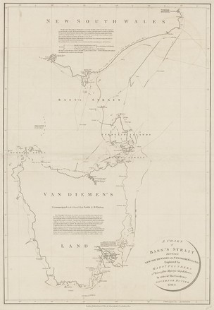
A Chart of Bass's Strait between New South Wales and Van Diemen's Land explored by Matt.w Flinders 2nd Lieut. of His Majesty's Ship Reliance by order of His Excellency Governor Hunter, 1798–9, 1801
Matthew Flinders
Published by A Arrowsmith, London
DL Cc 80 / 1
Published by A Arrowsmith, London
DL Cc 80 / 1
Separate voyages led George Bass and Matthew Flinders to share the view that a strait separated the mainland from Van Diemen’s Land (Tasmania). Flinders and Bass set out on the Norfolk to settle the matter – Flinders concentrated on charting and Bass documenting the land. Having satisfied themselves on the existence of the strait and island, at Flinders’ suggestion, Governor Hunter named the strait after Bass. This chart shows the tracks of George Bass's whaleboat (1797–98), Matthew Flinders’ Francis (1798) and Bass and Flinders’ Norfolk (1798–1799).