


First Sight: the Dutch mapping of Australia 1606-1697
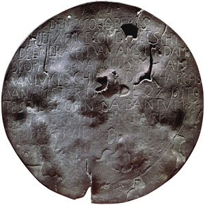
Dirk Hartog's pewter plate, 1616
Kindly lent by the Rijksmuseum, Amsterdam N.M. 825,363 mm
2006 is the four hundredth anniversary of the first documented sighting of Australia by Europeans. In March 1606, the Dutchman, Willem Janszoon, sailed down the west coast of Cape York as far as Cape Keerweer (turnabout) which he named.
This was the first in a succession of Dutch voyages in the seventeenth century which would result in the charting of almost two thirds of the Australian coastline. These include the voyages of Dirk Hartog, 1616; Jan Cartsenszoon, 1623; François Thijssen, 1627; Abel Tasman, 1642-1644; and Willem de Vlamingh, 1696-97.
Further charting of our coasts would not occur until James Cook charted the east coast in 1770.
Open:
6 March 2006 – 4 June 2006
Picture Gallery, Mitchell Wing
State Library opening hours
Admission: Free
Grateful acknowledgement is made to the Royal Netherlands Embassy, Canberra, and particularly Ambassador Hans Sondaal, for assistance with this exhibition.